
To quote Charles Dickens’ famous opening sentence from Tale of Two Cities: “It was the best of times, it was the worst of times, it was the age of wisdom, it was the age of foolishness…” well you know the rest. This passage could very well reflect the story of Candelaria and Metallic City.
I find myself traveling numerous times on US 95 between Las Vegas and Reno over the past several years. Always passing the Candelaria turn off road sign near the Redlich summit between the towns of Tonopah and Mina. Last week I decided that I would drive down the road near Pickhandle Gulch, named after the preferred weapon used to settling disputes, to see what remains of the once-bustling boomtowns Candelaria and Metallic City. Here are some of my findings.
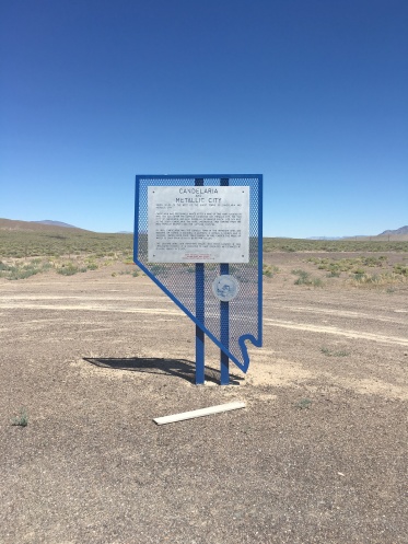
About 100 yards from the highway, travelers will find the State Historical Marker No. 92 for Candelaria and Metallic City. Sites for Candelaria and Metallic City can be found roughly 7 miles west of the State Historical Marker and US95. Not much remains of Candelaria except the remnants of a handful of buildings, a mill foundation and a cemetery. Metallic City on the other hand is in the vicinity of the active Kinross Gold Candelaria Mine on Mt. Diablo about ¾ mile south of Candelaria. I believe the town has long since been removed. Candelaria was considered the Saint City while Metallic City was considered the Sin City of its time due to alcohol, prostitution, and murders.

Mexicans prospectors first discovered silver ore in 1864, near what would become the Candelaria mining district. Candelaria was named after the Catholic ceremony Candlemas or the feast of the Presentation of the Lord. Although these prospectors settled the area, major mining operations didn’t develop until 1879 with the discovery of larger silver deposits.
One the major issues with this location was the lack of water to support any significant permanent population. Water was pumped and transported from a spring roughly nine miles away and cost a dollar a gallon. Whiskey at the time was less expensive than water. The stampmill, that crushes material by pounding rather than grinding, operated as a dry mill creating a large amount of particulates in the atmosphere, that settled in the lungs of the inhabitants, causing many to die of miner’s consumption otherwise called miner’s asthma.
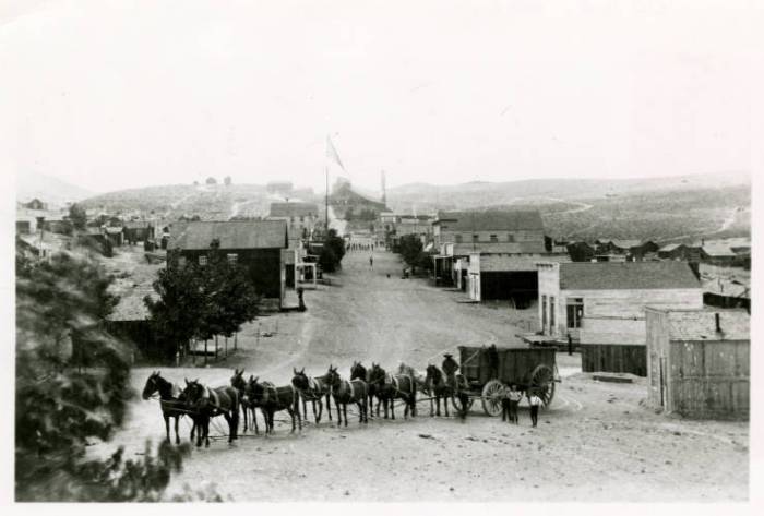
Beginning in 1880 the area began to prosper and became the largest town in the immediate area. In 1882, the establishment of a water pipe from trail Canyon caused the price of water to drop from $1 to $0.05 per gallon plus a secondary track for the Carson & Colorado railroad linked the town with the rest of the state allowed the town to prosper. The largest mine was called the Northern Belle that produced between $7 and $15 million in silver during its existence.


At its peak, Candelaria would boast two hotels, six stores, offices for three lawyers, three doctors and ten saloons. The Panic of 1893, triggered by the collapse of railroad overbuilding and shaky railroad financing, caused many of the mines to shut down. As a result most of the people deserted the town. The following seven years proved difficult for the remaining citizens; as the area was dry, windswept, and an isolated place. The remaining citizens endured by hoping for a recovery, that never came. By the late 1930’s, Candelaria was truly a ghost town.

Have you ever visit this ghost town?
GPS Coordinates: 38.15888 N, -118.08916 W

Hi Erik, I’ve never visited this place. This is the first one I haven’t been to. I love the pictures you take with this blog. It would be helpful if you included a map of Nevada with the location of the place you are talking about so we can see where it would be without having to google it.
LikeLike
Good point. I will see what I can do.
LikeLike
Do the maps and link at the end of the new blog help?
LikeLike
Yes, they do, but I actually like the GPS coordinates better. Is there a way to embed google maps into your post?
LikeLike
I will see.
LikeLike